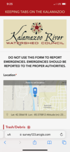
Welcome to the “Keeping Tabs on the Kalamazoo” Web Application Page
Use this smart phone web app to help us coordinate input from “many eyes on the water” and document NON-EMERGENCY concerns and stewardship action throughout the Kalamazoo River Watershed using your smart phone while you are outside enjoying this great southwest Michigan natural resource. Using the app is simple and fun, and you can see your uploads on a Google map to help track change and progress. And we only collect information that you enter or agree to, and only when you upload (aka “Submit”) an observation. Our public map of uploads only incudes the type, location, and time of observations you submit, along with photos that you include.
For EMERGENCIES, such as chemical spills or other immediate safety concerns, contact the proper authorities. The Michigan Department of Environment, Great Lakes, and Energy operates a “Pollution Emergency Alerting System” (PEAS) 24-hour hotline. Click HERE to go to the website. According to the PEAS website:
“An environmental emergency is a sudden threat to the public health or the well-being of the environment from the release or potential release of oil, radioactive materials, or hazardous chemicals into the air, land, or water. Report environmental emergencies to the:
Pollution Emergency Alerting System (PEAS) Hotline at 800-292-4706
This hotline is staffed 24 hours a day, seven days a week.”
Keeping Tabs App
The goal of “Keeping Tabs” is to help community members communicate their non-emergency water resources concerns from around the watershed to water resource practitioners and organizations that can help spur watershed/water quality improvements. The app can be used to capture positive experiences in the watershed, too, which are also very important to record. If your group is doing a creek, river, or lake cleanup somewhere in the watershed, use this app to document you stewardship efforts and help show that stewardship is happening all around the watershed. Repeated uses of the app at the same location (i.e., a long-term photo documentation point) can create a valuable record of changes over time (debris accumulation at a bridge, or growth of native plants at a recently restored area, for example). Having the observations go to a single app that is focused on the Kalamazoo River watershed helps highlight the cumulative benefit to the whole river of the many individual efforts taking place all around the watershed. All input from anyone willing to try out the app is welcome.
You can learn how to use the app from THIS DOCUMENT or THIS VIDEO. THIS LINK will take you to the app where you can bookmark it on your phone. The app is new, so please send us feedback via email to krwc@kalamazooriver.org.
Explore How People Have Been Using the App
A custom Google map available HERE shows key information from observations submitted by users of the app following a review of the original uploads by KRWC. Click an observation icon for more information about what was observed, including photos is provided.